モートン湾
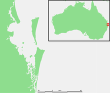
モートン湾の位置

マンリーのビーチ

1963年に座礁した船

スカボローの風景
モートン湾(Moreton Bay)は、ブリスベン(クイーンズランド州、オーストラリア)東19kmに位置する湾。魚釣りの行楽地、港湾(ブリスベン港)として機能。
目次
1 歴史
2 地理
3 参照
4 外部リンク
歴史
約6,000年前、氷河期終焉時の海面上昇による湾の形成
1770年5月15日、ジェームズ・クックはこの地域を通過した際に、王立協会長モートン卿に因んでモートン湾(Moreton Bay)と命名。モートン卿の名前は Morton であるが、クックの最初の航海記に現在の Moreton で記されているのはスペルミスだと考えられている[1]。 (Hawkesworth's Voyages[2])
1799年、マシュー・フリンダースはヨーロッパ人で最初に湾内を調査。
1823年、ジョン・オクスリーはブリスベン川を調査。受刑者、兵士が上陸。
1824年、オクスレイはモートン湾地域で最初の植民地を設置。
1830年代、ヨーロッパ人と先住民族(Quandamooka 族)の争い、ヨーロッパ人の銃によるアボリジニーの虐殺[3] 。
1850年代まで、材木輸送の港として機能。
2007年9月1日、湾内のボート事故で、4人死亡、10人負傷[4]
地理
- 3つの砂島:モートン島、ノース・ストラドブローク島、サウス・ストラドブローク島により、太平洋と隔たる
- 約360の島
- 一般的に浅く、砂で構成
参照
^ Ray Parkin, H. M. Bark Endeavour, Miegunyah Press, second edition 2003, ISBN 0-522-85093-6, page 226.
^ Voyages in the Southern Hemisphere, John Hawkesworth, 1773, volumes II-III, page 513 (online at the National Library of Australia).
^ Evans, Raymond (2007). A History of Queensland. Port Melbourne, Victoria: Cambridge University Press. pp. 46. ISBN 9780521876926.
^ "Four dead, 10 injured after boat collision". ABC News Online, 1 September, 2007
外部リンク
- Bribie Island Tourism and Business Directory
Moreton Bay Database - a detailed chronicle of events
BayJournal An online news source publishing one story a day about the Bay.
Raby Bay Weather Station A weather station on the shores of Moreton Bay with links to all things weather.
座標: 南緯27度15分 東経153度15分 / 南緯27.250度 東経153.250度 / -27.250; 153.250
[1] Folk song about the penal colony at Moreton Bay
Pencil drawing of Moreton Bay settlement, ca. 1835 [リンク切れ] by Henry Boucher Bowerman. Digitised and held by Heritage Collections, State Library of Queensland.


